
The Ancient Greeks resorted to passive solar design mainly because of acute firewoord shortages, but there was an additional reason: they believed that solar heat was good for human health. When solar access in cities regained attention in the western world during the urbanisation of the nineteenth and early twentieth centuries, health was the one and only motivation.
The Industrial Revolution brought plenty of cheap energy, but also plenty of disease. Millions of people ended up in overcrowded buildings in narrow streets. These neighbourhoods were soon ravaged by lethal epidemics such as tuberculosis, cholera, smallpox and typhoid fever. Most medical experts were convinced that these illnesses were caused by a lack of fresh air and sunshine.
In his 1893 book “Healthy Hospitals”, Douglas Galton wrote:
“Second only to air, is light and sunshine essential for growth and for health; and it is of Natures most powerful assistants in enabling the body to throw off those conditions which we call disease. Not only daylight, but sunlight; indeed, fresh air must be sun-warmed, sun-penetrated air. The sunshine of a December day has been recently shown to kill the spores of the anthrax bacillus.”
In 1854, John Snow famously observed that an outbreak of cholera could be traced back to the drinking of contaminated water at a public well, proving that the most devastating disease was not caused by foul air or a lack of sunshine but by germs in drinking water.
However, it would take half a century more before his theory was generally accepted. Furthermore, some ailments were indeed cured or alleviated by sunshine and fresh air. For example, rickets, a bone deforming disease endemic among children in nineteenth-century cities, was caused by a lack of sunshine.
At the turn of the century, doctors in Europe and in the US began promoting sunbathing to help prevent the disease. Interestingly, while Knowles initiated his research into the solar envelope purely for means of energy conversion, he gradually changed his priorities, aiming to improve the quality of life instead, of which he considers energy conversion to be just a part (see his latest book in particular).
Solar access in nineteenth-century cities
In order to ensure solar access and fresh air, many cities in Europe and in the United States enacted a variety of building codes between the 1850s and the 1930s. Although Knowles does not talk about this period, it is interesting to compare these earlier zoning practices to the solar envelope.
Most of the building codes were related to building height and street width. Boston architect William Atkinson, who was one of the advocates of passive solar design at the time, saw the limitations of these codes and pointed out that building shape was equally important – controlling it could actually improve development potential and solar access alike.
In his 1912 book “The Orientation of Buildings, or Planning for Sunlight”, he writes:
“The method of limiting the height of buildings by a horizontal plane, either at a fixed height, or at a height proportional to the width of the street, is simple in application but is not scientific, since it assumes that what is the proper height for the front wall or facade is also the proper height for the rear portions of the building.”
“Whereas, as a matter of fact, the rear portions may well be allowed to rise to a greater height, in proportion to their distance back from the street line. The height of the building should be limited by a slanting line drawn from the opposite side of the street at a certain angle.”
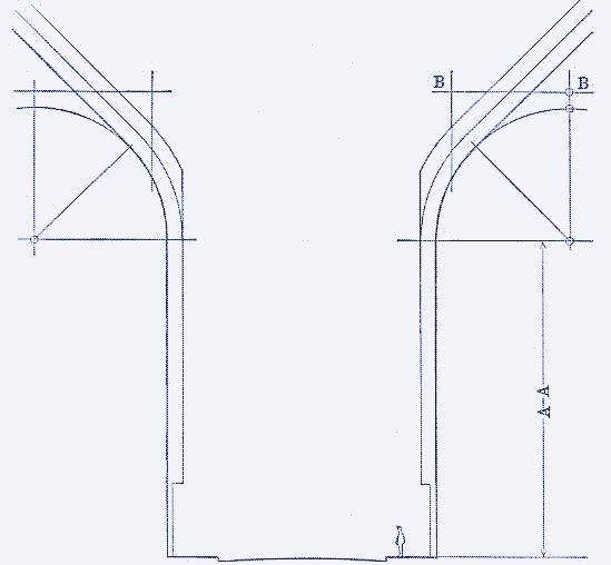
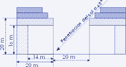
Atkinson was inspired by the 1902 building laws of Paris (an adaptation of the original building codes made by Haussmann), which not only contained rules about street width and building height, but also introduced a code regulating building shape. The illustration above (taken from Atkinson’s book) shows that the facade of a Paris building (the vertical A-A line) could not be higher than 20 metres, while the attics above (of which the height was also determined by street width but could not surpass 10 metres) were curved.
This made it more likely for sunlight to penetrate the lower parts of the building on the other side of the street, while maximizing housing density. England’s capital had somewhat similar building codes since the 1894 London Building Act, though prescribing slanting roofs instead of curved ones (illustration on the left). The tiered skyscrapers that appeared in the US following the 1916 Standard Zoning Enabling Actalso regulated building shape, although the sheer height of the buildings was unfavourable for solar access.
The Barcelona Eixample
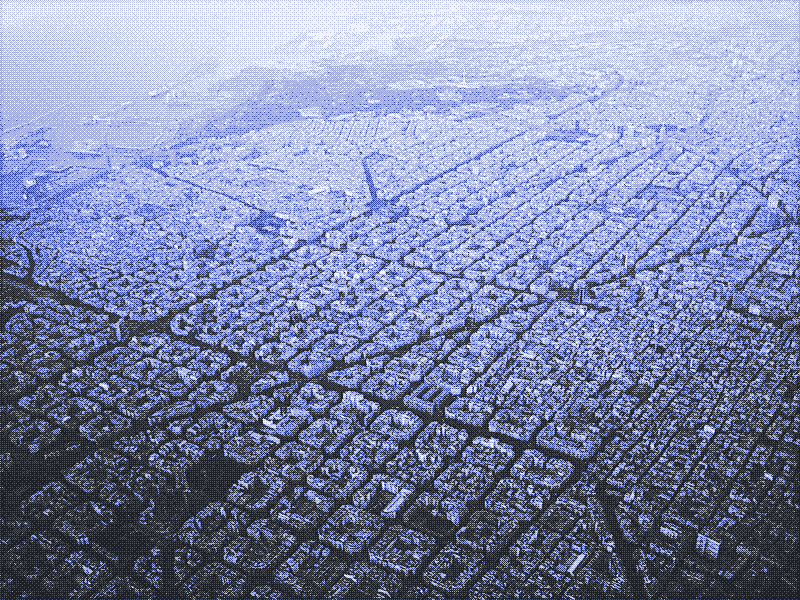
The most interesting example of nineteenth-century solar city planning is the Barcelona “Eixample” (Catalan for “enlargement” or “expansion”), designed by Ildefons Cerdà i Sunyer. The Barcelona Eixample (home to the Sagrada Familia and other famous Gaudí monuments) can be considered the largest solar-planned neighbourhood in existence. Moreover, its history exemplifies the tension between solar access and developmental needs.
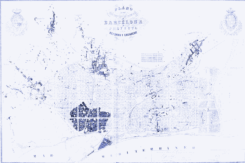
Unlike Baron George-Eugène Haussmann in Paris, Cerdà did not have to demolish Barcelona to adapt the city to the massive immigration flow of the period. Medieval Barcelona (the large dark blob on the map above) was surrounded by a large open plain with only a few small villages at the outskirts (also in black).
In the 1850s, Cerdà designed a large ‘checkerboard’ street plan surrounding the old city centre and annexing the periferial towns. The neighbourhood, which today has an area of 7.46 km2, consists of streets 20 metres wide (65.5 ft), intersected by a few boulevards 50 metres wide (164 ft), and very large city blocks measuring 113 x 113 metres (370 x 370 ft).
Cerdà intended to maximize solar access (and ventilation) to every apartment in four ways. Firstly, he limited building height to 16 metres (52.5 ft) for streets 20 metres wide. Furthermore, he mandated that city blocks could only be built up on two instead of four sides, either parallel to each other or in the form of an L (illustration on the right, below). This enabled the creation of large interior spaces and introduced sunlight and fresh air at both sides of each building.
The Barcelona Eixample can be considered the largest solar planned neighbourhood in existence today
Thirdly, all city blocks have truncated corners, further improving solar access. Lastly, he decided not to lay the street grid on the cardinal points, but diagonal to it. As we will see shortly, this gave all apartments access to sunlight during the day, while offering all streets shadow throughout the day.

Only the truncated corners and the orientation of the streets survived one hundred and fifty years of history. Cerdà’s plan received much criticism at the time. The main reproach was that the design wasted too much valuable building space and thus money.
Within years, all four sides of every octagonal city block were built up. Even most of the smaller interior spaces that resulted from this were filled, albeit with low buildings so that solar access at the rear facades remained more or less intact. Gradually, the laws regarding building height were relaxed, from the original 16 metres (52 ft) to almost 30 metres (98 ft).
However, solar access was retained on all floors of the buildings on the other side of the street by placing the top floors somewhat further back—in fact, producing a terraced building similar in shape to those of the Native Americans (See part 1). In this way, developers looking for financial profit actually improved housing density without negatively impacting solar access.
The terraced upper buildings and the truncated corners in Barcelona, as well as the curved roofs in Paris and the slanted roofs in London, can all be considered embryonic steps towards Knowles’ solar envelope. However, he improved the concept substantially in two ways. Firstly, he applies the idea of the sloping line to the whole building, not just the roof or the upper floors.
Secondly, his slanting lines coincide precisely with the rays of the sun, which was not necessarily the case in these earlier examples. To add to this, the earlier building codes produced monotonous architectural forms and street views, while the buildings under the solar envelope can be diverse, depending on their specific location and surroundings.
The solar envelope and street orientation
The size and shape of a solar envelope is influenced by the orientation of the streets. In the US, city layout is usually based on orderly subdivisions that have geometricised the land. Typically, throughout the midwest and the west, streets run in line with the cardinal points so that rectangular blocks extend in the east-west and north-south direction of the Jeffersonian grid (or US Land Ordinance, enforced in 1785).
In the southern US, as well as in large parts of Latin America, a similar grid appears, with the difference that it is oriented diagonally at the cardinal points, with streets extending northeast-southwest and northwest-southeast. These grids were laid out according to the Law of the Indies, a manual for the construction and administration of colonial communities compiled by the King of Spain in 1573.
In Europe there are relatively few gridirion city lay-outs to be found. The existence of older city fabrics, resulting from centuries of unregulated growth during the middle ages and the Renaissance, constrained experiments with urban planning. Many European cities were ‘modernised’ at the turn of the twentieth century, by laying out wide streets and boulevards that cut through the older parts of the city - Paris being the most (in)famous example - but basically randomness still rules. The solar envelope can be applied to all possible street layouts, even if they’re chaotic, with differing results.
William Atkinson: avoid east-west, north-south
In “The Orientation of Buildings, or Planning for Sunlight”, William Atkinson devotes a chapter to the importance of street orientation for solar planning. He argues that the Jeffersonian grid should be avoided in order to provide optimal solar access for cities. Instead, he follows Cerdà and backs the Spanish grid:
“When streets are laid out at right angles to each other according to the checkerboard plan, the best distribution of sunlight is obtained when one series of streets runs northeast-southwest and the other northwest-southeast. It is unfortunate that in so many cases where the ‘checkerboard’ plan has been adopted, the streets have been laid out north-south and east-west, which is the worst arrangement possible.”
In an east-west street the surface of the street receives no sunlight at all during six months of the year
Atkinson agrees that “if we were to base our judgment wholly on the amount of sunlight received by windows, we should conclude that the best position for a building is with its long axis placed east and west”. However, he saw an important disadvantage with this orientation: it involves an area of “complete shadow” on the north side of the building, during one half of the year (autumn to spring), while in the case of a building with its diagonal upon the meridian all sides receive sunlight throughout the year. The same goes for the streets:
“In an east-west street the surface of the street receives no sunlight at all during six months of the year, and the buildings on the south side of the street are in perpetual shadow. In contrast, when the streets are oriented diagonal upon the cardinal points, the buildings shade the surface of the ground much less”.
Ralph Knowles: it depends
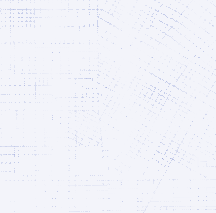
Knowles did most of his research in Los Angeles, which makes it easy to compare both grid patterns—LA consists of both an older Spanish grid and a newer Jeffersonian grid (illustration on the right). Knowles acknowledges that the Jeffersonian grid is not an ideal solution:
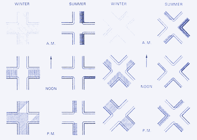
“Streets that run east-west in a built-up area will tend to be shadowed during all of a winter day. The streets thus remain dark and cold. By contrast, streets that run north-south are lighted and warmed during the midday. In summer, streets that run north-south will be shadowed in the morning and the afternoon, but will receive the full force of the midday sun.”
“From the viewpoint of solar orientation, the Jeffersonian grid leaves something to be desired. Its east west streets are too dark and cold in winter, its north south streets too bright and hot in summer. In Los Angeles, the older Spanish grid seems to have advantages regarding street qualities of light and heat. During the winter, every street receives direct light and heat from the sun somewhere between 9 am and 3 pm, the six hours of greatest radiation. Every street has the advantage of some shadow during most of the summer day.”
The grid layout best suited for both maximum solar access and maximum building density is one with rectangular blocks running long in the east-west direction
On the other hand, the classic grid plan oriented at the cardinal points also has benefits. Knowles demonstrates that the solar envelope over a city block oriented on the cardinal points will contain more developeable volume than one over a diagonal block:
“Generally, the most height, and hence volume, are attainable at either of the two block orientations within the Jeffersonian grid, and the least volume is attainable at about the angular orientation of the Spanish grid. The street’s gain in sunlight thus appears to be the developer’s lose. Other design values can dictate grid orientation but, for volume alone, the Jeffersonian grid has the advantages.”
Within the Jeffersonian grid, sites oriented in the east-west direction allow a greater volume of development under the solar envelope than sites running north-south. Knowles calculated that, given the same site shape and proportions of 1:3, a building site oriented long on an east-west axis will generate 40 percent more volume and 400 percent more south face over the north-south orientation.
In short, the grid layout best suited for both maximum solar access and maximum building density is one with rectangular blocks running long in the east-west direction - as was the case in the Ancient Greek solar communities and in Acoma Pueblo.
Combining the best of both grids
One problem remains, though. Within our cities, the orientation of houses is toward the street rather than toward the sun. If a street runs east-west, only the buildings on the north side of the street will have south exposure at their street front (providing that the buildings on the south side of the street do not shadow them).
The buildings on the south side of the street have south exposure only at their rear facades. If a street runs north-south (and a grid system having desirable east-west streets will by definition have north-south streets, too), none of the buildings will have the ideal south exposure.
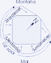
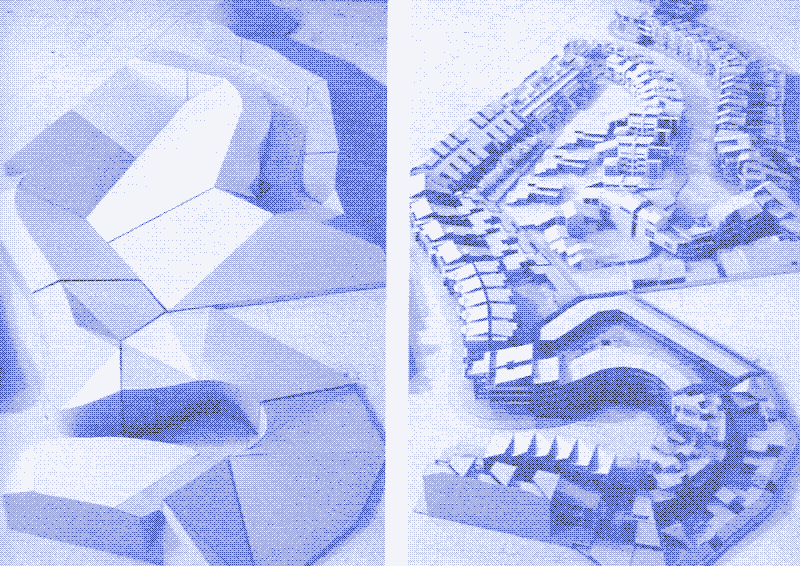
To solve this problem, Knowles reverts to the solution provided by the Ancient Greeks, using courtyards and alleys that are curved out from the middle of the site (See part 1 —). Moreover, he shows that the concept can be further improved upon. This can be seen in the Bunker Hill Project, in which a solar envelope was calculated for a large vacant lot on the Spanish grid in downtown Los Angeles.
One of the building designs made to fit this solar envelope, consists of an internal and separate street composed of a sequence of large and small squares, cascading diagonally across the site from its higher edge to its lower edge.
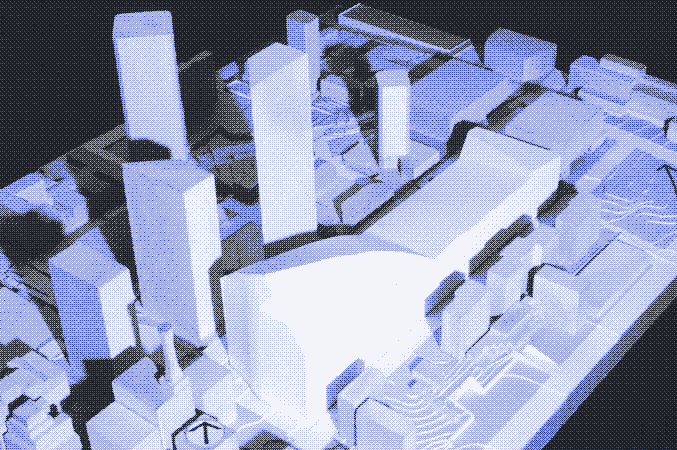
During the midday hours, the sun sees down the entire length of the interior street because it runs more nearly in a north-south direction, diagionally across the street. At 3 pm in winter, the public space is still in sunlight, as is the entire length of the interior street on its southeastern side. “Such sensitive tuning of the building’s location and form”, writes Knowles, " combine the best aspects of both the Spanish grid and the Jeffersonian grid."
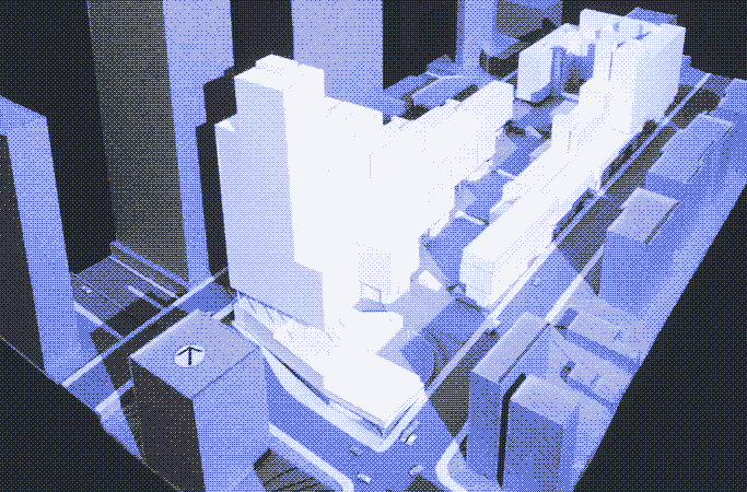
above. Note the shadows, at 3 pm in winter.
When aiming to combine the advantages of solar access and wind conditions, similar compromises can be found. Knowles:
“Sometimes complex sets of environmental forces act congruently so that, for example, desirable sun and wind may come from the same direction. In this fortunate circumstance, the building may be oriented to catch both sun and wind on its broad south face and the building may thus be open on that side. On the other hand, directional forces more usually act incongruently, making choices necessary.”
“The sun and wind may come from different directions. Where choices exist, values must be set. For example, the sun may be recognized through a primary locational adaptation in which the whole building becomes oriented to the south. Adaptation to a west wind would then be handled with a secondary form mode in which the building’s surface structure scoops in the wind for natural ventilation.”
Sources
- “Ritual House: Drawing on Nature’s Rhythms for Architecture and Urban Design”, Ralph L. Knowles, 2006.
- “Sun Rhythm Form”, Ralph L. Knowles, 1981
- “Energy and Form: An Ecological Approach to Urban Growth”, Ralph L. Knowles, 1974
- “A Golden Thread: 2500 Years of Solar Architecture and Technology”, Ken Butti and John Perlin, 1981, reprinted in 2009
- “The orientation of buildings, or planning for sunlight”, William Atkinson, 1912
- “Teoría general de la urbanización y aplicación de sus principios y doctrinas a la reforma y ensanche de Barcelona”, Ildefons Cerdà i Sunyer, 1867
- “Ildefonso Cerdá”, “Distrito del Ensanche” & “Plan Cerdá”, Wikipedia Spanish - “Walks Through Lost Paris: A Journey Into the Heart of Historic Paris”, Leonard Pitt, 2006
- “Responsive and sustainable architectural strategies for temperate regions”, S.M. Mofidi, 2005 (PDF) - “The City as a Work of Art: London, Paris, Vienna”, Donald J. Olsen, 1986
- “Spanish city planning in North America”, Dora Crouch, Daniel Garr, Axel Mundigo, 1982
- “The Density Atlas”, MIT (website) - “Visualizing density” (PDF)